As part of your skills development in GCSE geography, you will have learnt about map scales, working out distances and directions from Ordnance Survey and other maps. Without a scale, a map is of little use. It can show you how the features in an area are related to one-another but it gives no idea of distance. The earliest maps were all hand drawn and scales were not particularly accurate which made using them quite difficult.
A map represents a sector of landscape. Large scale maps show a small area in great detail whilst a small scale map shows a much larger area but in less detail. This can be a little confusing at first as the scale number of a large scale map is smaller. A 1:100,000 scale map is a small scale map but 1:5,000 is a large scale map.
[readmore]
The scale number on an OS map indicates how many centimetres on the ground are represented by a centimetre on the map. On a 1:100,000 scale map, one centimetre on the map represents 100,000 cm on the ground, in other words, one centimetre on the map represents one kilometre in reality. A scale of 1:5,000 therefore means that a centimetre on the map represents a distance in real life of 5,000 centimetres (50 metres). This method of representing the scale of a map is called the fractional method, but you will also see graphical representations or written representations like 2 cm = 1 km.
Ordnance Survey maps are printed with north at the top. East is therefore to the right, south to the bottom and west to the left. The four points north, east, south and west are called the cardinal points of the compass. There are four other directions exactly half-way between the cardinal points - north-east, south-east, south-west and north-west. These are often abbreviated to NE, SE, SW and NW. Between these and the cardinal points, there are eight others, each beginning with the closest cardinal point e.g. the direction between north and north-east is called north-north-east. Using these descriptions for a direction is usually sufficient unless you are trying to navigate in difficult terrain. Then you need to use exact compass bearings. North is a bearing of zero degrees, east is ninety degrees, south is one hundred and eighty degrees and west is two hundred and seventy degrees. If you were required to follow a bearing of thirty degrees, you would be travelling in a direction somewhere between NNE and NE.
[/readmore]
To see a larger image, click on the picture.
|
1.
|
This is a picture of an actual road sign in use in Switzerland. If you were using a road map with a scale of 1:100,000, how many cm from the location of the sign would Lugano be? 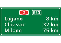
|
|
| [ ] |
8 cm |
| [ ] |
32 cm |
| [ ] |
75 cm |
| [ ] |
100 cm |
|
|
|
2.
|
If you were drawing a map of the Warrego Highway, how many cm would you need between Ipswich and Toowoomba? 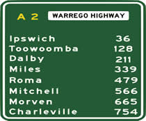
|
|
| [ ] |
128 at a scale of 1:25,000 |
| [ ] |
184 at a scale of 1:50,000 |
| [ ] |
92 at a scale of 1:75,000 |
| [ ] |
All of the above are correct |
|
|
|
3.
|
The Togolese Republic in Africa lies on the Prime Meridian of the World. In which direction is it from London? 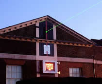
|
|
| [ ] |
North |
| [ ] |
East |
| [ ] |
South |
| [ ] |
West |
|
|
|
4.
|
The photo shows a picture of Leeds, a large city in the UK. On an OS map, scale 1:50,000, a student drew a line, direction 90° east for 2 cm then continued it for 2 cm, in direction 180° followed by 2 cm in direction 270°. In the landscape, how far away from the starting point is the end point? 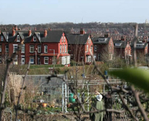
|
|
| [ ] |
0.5 km |
| [ ] |
1.0 km |
| [ ] |
2.0 km |
| [ ] |
0.0 km |
|
|
|
5.
|
A group of students on an exchage trip to France were given a town map. They needed to get to the station (marked B on the plan) as quickly as possible. They were at point A on the map. In which direction did they need to walk? 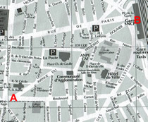
|
|
| [ ] |
South east |
| [ ] |
South west |
| [ ] |
North west |
| [ ] |
North east |
|
|
|
6.
|
The scale of this plan is 1:5,000. Each grid square measures 2 cm x 2 cm. What area is represented by one grid square? 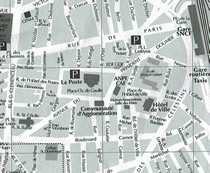
|
|
| [ ] |
0.01 square kilometres |
| [ ] |
1 hectare |
| [ ] |
10,000 square metres |
| [ ] |
All of the above |
|
|
|
7.
|
The photograph shows a trig pillar. What were they used for? 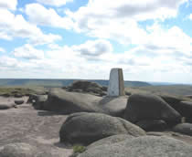
|
|
| [ ] |
They were used by the Ordnance Survey for accurate surveying to help them to produce maps |
| [ ] |
They were built during the second world war for defence purposes |
| [ ] |
They were used as emergency stations to help lost hikers |
| [ ] |
They were used as rain guages |
|
|
|
8.
|
Which of the following scales would be appropriate to produce a plan of your school and school grounds? 
|
|
| [ ] |
1:100,000 |
| [ ] |
1:500,000 |
| [ ] |
1:5,000 |
| [ ] |
1:50,000 |
|
|
|
9.
|
Montreal is a city in Canada. Its coordinates are 45.5° N, 73.6° W. Which of the following European cities would be almost exactly due east of Montreal? 
|
|
| [ ] |
London (51.5° N, 0.13° W) |
| [ ] |
Berlin (52.5° N, 13.4° E) |
| [ ] |
Oslo (59.9° N, 10.8° E) |
| [ ] |
Lyon (45.8° N, 4.8° E) |
|
|
|
10.
|
Using an OS map of the Peak District, the source of the river Ashop is in grid square 0691. It flows a few kilometres into Ladybower reservoir in grid square 1687. In which general direction does it flow? 
|
|
| [ ] |
Slightly west of north |
| [ ] |
Due south |
| [ ] |
Slightly south of east |
| [ ] |
Due east |
|
|
|
1.
|
This is a picture of an actual road sign in use in Switzerland. If you were using a road map with a scale of 1:100,000, how many cm from the location of the sign would Lugano be?
|
|
| [x] |
8 cm |
| [ ] |
32 cm |
| [ ] |
75 cm |
| [ ] |
100 cm |
|
|
|
2.
|
If you were drawing a map of the Warrego Highway, how many cm would you need between Ipswich and Toowoomba?
|
|
| [ ] |
128 at a scale of 1:25,000 |
| [x] |
184 at a scale of 1:50,000 |
| [ ] |
92 at a scale of 1:75,000 |
| [ ] |
All of the above are correct |
|
|
|
3.
|
The Togolese Republic in Africa lies on the Prime Meridian of the World. In which direction is it from London?
|
|
| [ ] |
North |
| [ ] |
East |
| [x] |
South |
| [ ] |
West |
|
|
|
4.
|
The photo shows a picture of Leeds, a large city in the UK. On an OS map, scale 1:50,000, a student drew a line, direction 90° east for 2 cm then continued it for 2 cm, in direction 180° followed by 2 cm in direction 270°. In the landscape, how far away from the starting point is the end point?
|
|
| [ ] |
0.5 km |
| [x] |
1.0 km |
| [ ] |
2.0 km |
| [ ] |
0.0 km |
|
|
|
5.
|
A group of students on an exchage trip to France were given a town map. They needed to get to the station (marked B on the plan) as quickly as possible. They were at point A on the map. In which direction did they need to walk?
|
|
| [ ] |
South east |
| [ ] |
South west |
| [ ] |
North west |
| [x] |
North east |
|
|
|
6.
|
The scale of this plan is 1:5,000. Each grid square measures 2 cm x 2 cm. What area is represented by one grid square?
|
|
| [ ] |
0.01 square kilometres |
| [ ] |
1 hectare |
| [ ] |
10,000 square metres |
| [x] |
All of the above |
|
|
|
7.
|
The photograph shows a trig pillar. What were they used for?
|
|
| [x] |
They were used by the Ordnance Survey for accurate surveying to help them to produce maps |
| [ ] |
They were built during the second world war for defence purposes |
| [ ] |
They were used as emergency stations to help lost hikers |
| [ ] |
They were used as rain guages |
|
|
|
8.
|
Which of the following scales would be appropriate to produce a plan of your school and school grounds?
|
|
| [ ] |
1:100,000 |
| [ ] |
1:500,000 |
| [x] |
1:5,000 |
| [ ] |
1:50,000 |
|
|
|
9.
|
Montreal is a city in Canada. Its coordinates are 45.5° N, 73.6° W. Which of the following European cities would be almost exactly due east of Montreal?
|
|
| [ ] |
London (51.5° N, 0.13° W) |
| [ ] |
Berlin (52.5° N, 13.4° E) |
| [ ] |
Oslo (59.9° N, 10.8° E) |
| [x] |
Lyon (45.8° N, 4.8° E) |
|
|
|
10.
|
Using an OS map of the Peak District, the source of the river Ashop is in grid square 0691. It flows a few kilometres into Ladybower reservoir in grid square 1687. In which general direction does it flow?
|
|
| [ ] |
Slightly west of north |
| [ ] |
Due south |
| [x] |
Slightly south of east |
| [ ] |
Due east |
|
|