USUS UKUKIndiaIndia

Every Question Helps You Learn

Join Us
Streak
Leading Streak Today
Your Streak Today
Streak
Leading Streak Today
Your Streak Today
Weather Forecasting
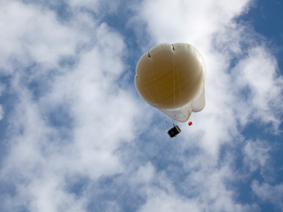
Weather balloons are one of the tools used by forecasters.

Weather Forecasting

This Geography quiz is called 'Weather Forecasting' and it has been written by teachers to help you if you are studying the subject at middle school. Playing educational quizzes is a fabulous way to learn if you are in the 6th, 7th or 8th grade - aged 11 to 14.

It costs only $12.50 per month to play this quiz and over 3,500 others that help you with your school work. You can subscribe on the page at Join Us

In 1859 the sailing ship Royal Charter steamed past the safety of the port of Holyhead, trying to reach Liverpool in time to maintain her record as one of the fastest ships. She anchored off the coast of Wales to wait for a pilot to take her into Liverpool docks. There was no need to rush, the weather seemed calm and non-threatening. But appearances can be deceptive. A storm struck and by the morning the ship had been driven onto the rocks and 400 of her passengers were dead. In that one storm, which had hurricane force winds, 800 people died, 133 ships were sunk and most of the British fishing fleet was driven ashore.

The tragedy, which became known as the Royal Charter Storm, was the catalyst for the start of a new type of national science, weather forecasting, and a new organization, the National Meteorological (or Met) Office. Initial forecasting was done using visual observations and measuring the barometric pressure. Now computers, radar and satellite images can tell us exactly what is happening in the clouds and where they are. This gives us a prediction as to where those clouds are going. Networks of weather stations and weather buoys send information to the meteorological station. There is even a weather station on a set of moors in England that is frequently used by scientists to tell them the weather conditions for their experiments in how bodies rot.

The science of weather forecasting has developed massively in the 150 years plus since that tragedy, but the Met Office still on occasion gets it wrong!

1.
Which of the following is not used in forecasting?
Moisture content in the oceans
Cloud cover and cloud types
Moisture content in the atmosphere
Atmospheric pressure
The moisture content in the oceans is always 100%! The temperature of the oceans is measured though, as are the ocean currents
2.
Which of the following are not normally forecasted by the Met Office?
Pollen
Precipitation
Windspeed
River levels
River levels are commonly forecasted by the environment agency
3.
A radiosonde measures atmospheric parameters and transmits them to a receiver on the ground. What are radiosondes normally attached to?
Weather balloons
Surface monitoring buoys
Land stations
Ship based monitoring
You may not have heard of a radiosonde but the question gives you some more clues. It hints at the idea that the radiosonde is above the ground, so it must be attached to a weather balloon
4.
Which of the following professions and industries are not offered specialist training by the Met Office?
Marine industries
Rail industries
Renewable energy specialists
Teachers
PIlots, road operators, water management industries, broadcasters, retail operators and climate change scientists are also offered training in weather forecasting and how to react to the changing conditions. Teachers just have to read the forecast themselves and make the best of it!
5.
Lines of equal atmospheric pressure on a weather map or a synoptic chart are known as what?
Isobars
Cold Fronts
Warm Fronts
Isolines
Air pressure tends to range between 890mb and 1060mb
6.
A synoptic chart summarizes atmospheric conditions. Which of the following is not commonly shown on a synoptic chart?
Temperature
Sea state
Precipitation
Atmospheric pressure
Synoptic charts commonly show temperature, precipitation, wind speed and direction, atmospheric pressure and cloud coverage
7.
How can ocean waves be predicted and forecasted?
Ocean waves are generated thousands of miles away and can be tracked
Ocean waves are generated by the sea floor geology which has been modeled
Ocean waves are driven by wind power and wind strength and direction can be predicted
Ocean waves are driven only by storms in the middle of the ocean which can be mapped and predicted
Ocean waves are driven by wind power. Sometimes the wind may have been driving the waves for hundreds, or in the Southern Ocean thousands, of miles
8.
Low pressure and tight isobars tend to lead to what sort of weather?
Hot and sunny
Dry and windy
Wet and windy
Wet and calm
In low pressure areas, water vapor rises, cools and condenses as precipitation, while tight isobars mean that the pressure is changing rapidly, leading to a greater wind speed
9.
What is an anticyclone more commonly known as?
High Pressure
Low Pressure
A hurricane
A typhoon
When anticyclones form in the summer we get warm, sunny and dry weather. During the winter the same conditions can be sunny, but extremely cold
10.
What is atmospheric or barometric pressure measured in?
Pounds per square inch (PSI)
Kilograms (kg)
Pascals (Pa)
Millibars (mb)
Atmospheric pressure is created by the weight of the air above us and is the amount of force it exerts downwards per square meter
Author:  Ruth M

© Copyright 2016-2024 - Education Quizzes
Work Innovate Ltd - Design | Development | Marketing

We use cookies to make your experience of our website better.

To comply with the new e-Privacy directive, we need to ask for your consent - I agree - No thanks - Find out more