


Ask the AI Tutor
Need help with Scale Drawings and Maps (F)? Ask our AI Tutor!
AI Tutor - Lucy
Connecting with Tutor...
Please wait while we establish connection
Test your skills with maps and scale drawings by playing this quiz.
Scale Drawings and Maps (F)
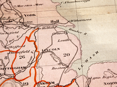
Understand scale drawings and maps: read ratios, convert units, and use scale factors to find real distances, lengths and areas.
Question 1
/Q1.PNG)
/Q1a1.PNG)
/Q1a2.PNG)
/Q1a3.PNG)
/Q1a4.PNG)
/Q1hc.PNG)
Question 2
/Q2.PNG)
/Q2a1.PNG)
/Q2a2.PNG)
/Q2a3.PNG)
/Q2a4.PNG)
/Q2hc.PNG)
Question 3
/Q3.PNG)
/Q3a1.PNG)
/Q3a2.PNG)
/Q3a3.PNG)
/Q3a4.PNG)
/Q3hc.PNG)
Question 4
/Q4.PNG)
/Q4a1.PNG)
/Q4a2.PNG)
/Q4a3.PNG)
/Q4a4.PNG)
/Q4hc.PNG)
Question 5
/Q5.PNG)
/Q5a1.PNG)
/Q5a2.PNG)
/Q5a3.PNG)
/Q5a4.PNG)
/Q5hc.PNG)
Question 6
/Q6.PNG)
/Q6a1.PNG)
/Q6a2.PNG)
/Q6a3.PNG)
/Q6a4.PNG)
/Q6hc.PNG)
Question 7
/Q7.PNG)
/Q7a1.PNG)
/Q7a2.PNG)
/Q7a3.PNG)
/Q7a4.PNG)
/Q7hc.PNG)
Question 8
/Q8.PNG)
/Q8a1.PNG)
/Q8a2.PNG)
/Q8a3.PNG)
/Q8a4.PNG)
/Q8hc.PNG)
Question 9
/Q9.PNG)
/Q9a1.PNG)
/Q9a2.PNG)
/Q9a3.PNG)
/Q9a4.PNG)
/Q9hc.PNG)
Question 10
/Q10.PNG)
/Q10a1.PNG)
/Q10a2.PNG)
/Q10a3.PNG)
/Q10a4.PNG)
/Q10hc.PNG)


**Unlimited Quizzes Await You! 🚀**
Hey there, quiz champ! 🌟 You've already tackled today's free questions.
Ready for more?
Ready for more?
🔓 Unlock UNLIMITED Quizzes and challenge yourself every day. But that's
not all...
not all...
🔥 As a Subscriber you can join our thrilling "Daily Streak" against other
quizzers. Try to win a coveted spot on our Hall of Fame Page.
quizzers. Try to win a coveted spot on our Hall of Fame Page.
Don't miss out! Join us now and keep the fun rolling. 🎉
**Unlimited Quizzes Await You! 🚀**
Hey there, quiz champ! 🌟 You've already tackled today's free questions. Ready for more?
🔓 Unlock UNLIMITED Quizzes and challenge yourself every day. But that's not all...
🔥 As a Subscriber you can join our thrilling "Daily Streak" against other quizzers. Try to win a coveted spot on our Hall of Fame Page.
Don't miss out! Join us now and keep the fun rolling. 🎉
© Copyright 2016-2026 - Education Quizzes
Work Innovate Ltd - Design | Development |
Marketing