


Ask the AI Tutor
Need help with Landform Use and Tectonic Plates? Ask our AI Tutor!
AI Tutor - Lucy
Connecting with Tutor...
Please wait while we establish connection
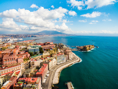
Mount Vesuvius.
Landform Use and Tectonic Plates
Tectonic plates shape our planet, building mountains, trenches, and valleys. This GCSE Geography quiz links plate movements to landforms and how people use these dramatic landscapes.
1 .
Which of the following features is created at a destructive plate boundary?
A crater
Fold mountains
Pillow lava
A rift valley
Rift valleys are created where the Earth's crust is being pulled apart by tectonic movements, pillow lava is created at undersea constructive plate margins
2 .
Iceland is right on the constructive plate boundary between the Eurasian plate and the North American plate. Which of the following statements is correct?
Many Icelanders are killed each year by volcanic eruptions
Iceland can use geothermal energy to generate electricity
Iceland is an uninhabited island because of the volcanoes
It is not possible to farm on Iceland
The magma that comes out of the volcanoes in Iceland heats up the ground sufficiently hot to be used for geothermal power stations
3 .
On which slopes of fold mountains in the SOUTHERN hemisphere would agriculture be most likely to take place?
East
South
West
North
In the southern hemisphere, the northern slopes are facing the Sun - it is the opposite to the northern hemisphere where the southern slopes are the sunniest
4 .
Which of the following is NOT a direct human use of fold mountains?
Winter sports
Agriculture
Mobile telephone manufacture
Electricity production
Tourism, agriculture and hydroelectric power generation are important uses of this landform. There could be mobile telephone manufacturing in urban areas that have developed in fold mountains, but they are not there because of the mountains
5 .
The three types of plate boundary are:
destructive, constructive and conservative
sideways, upwards and downwards
always passing each other on the left
locked in place
Each produces unique landform features
6 .
Why do people live near to active volcanoes?
The soils can be very fertile
The heat from the volcano creates a warm climate
To save money on heating bills
Houses near volcanoes are all a lot cheaper than other houses
The fertile soils mean that farming will be more productive. There are long periods of time between eruptions so most of the time, the people living there are in no danger from the volcano. Volcanologists can usually give several days warning before an eruption
7 .
In fold mountains, roads usually follow the line of which of the following features?
Pyramidal peaks
Aretes
Valleys
Scree slopes
Roads in valleys are less exposed to the weather and are easier to construct
8 .
Which of the following methods of generating electricity is MOST likely to be developed in a mountainous area?
Biogas
Hydroelectric
Nuclear
Geothermal
For the GCSE, you should associate geothermal energy generation with volcanic landforms. Fold mountains often have deep, steep-sided valleys which can easily be dammed to provide lakes for hydroelectric power schemes
9 .
The management of coniferous forests is an important use of fold mountains. Which of the following is NOT a use of these forests?
Generating electricity on a large scale
Fuel for heating homes
Providing timber for building
Providing an area for leisure activities
It is important to manage forests sustainably to ensure this renewable resource will continue to be available to future generations of humans
10 .
Which of the following statements is NOT correct?
Tourism in fold mountains occurs all year round
Volcanic soils are often very fertile
Road and rail communications in fold mountains can be difficult
Tourists are not allowed to visit volcanoes
Many volcanoes, including some which are dormant or still active attract tourists. This is possible because they are closely monitored so that volcanologists can say whether there is about to be an eruption


**Unlimited Quizzes Await You! 🚀**
Hey there, quiz champ! 🌟 You've already tackled today's free questions.
Ready for more?
Ready for more?
🔓 Unlock UNLIMITED Quizzes and challenge yourself every day. But that's
not all...
not all...
🔥 As a Subscriber you can join our thrilling "Daily Streak" against other
quizzers. Try to win a coveted spot on our Hall of Fame Page.
quizzers. Try to win a coveted spot on our Hall of Fame Page.
Don't miss out! Join us now and keep the fun rolling. 🎉
**Unlimited Quizzes Await You! 🚀**
Hey there, quiz champ! 🌟 You've already tackled today's free questions. Ready for more?
🔓 Unlock UNLIMITED Quizzes and challenge yourself every day. But that's not all...
🔥 As a Subscriber you can join our thrilling "Daily Streak" against other quizzers. Try to win a coveted spot on our Hall of Fame Page.
Don't miss out! Join us now and keep the fun rolling. 🎉
© Copyright 2016-2026 - Education Quizzes
Work Innovate Ltd - Design | Development |
Marketing