


Ask the AI Tutor
Need help with Limestone and Chalk Features? Ask our AI Tutor!
AI Tutor - Lucy
Connecting with Tutor...
Please wait while we establish connection
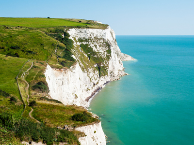
The White Cliffs of Dover are an example of a chalk and limestone landscape.
Limestone and Chalk Features
Limestone and chalk form dramatic landscapes with pavements, gorges, and caves. This GCSE Geography quiz tests how these rocks shape scenery and support distinctive plants and wildlife.
1 .
Stalactites are composed of layers of calcium carbonate. Why are stalactites more common in limestone regions?
The water is alkaline and so doesn't dissolve the limestone
Limestone regions are the only place that contain caves. Caves have the damp atmosphere that is crucial for stalactite formation
As the water runs through the limestone it picks up imperfections such as sand and deposits these in the form of limestone
As water runs through limestone it dissolves the limestone and deposits this as it drips off the roof of caves in the limestone
Stalactites are layers of dissolved limestone, or other types of calcium carbonate. As the water runs down the formation it leaves behind some of that dissolved limestone
2 .
Limestone is frequently quarried for a variety of uses, often in national parks and areas of outstanding natural beauty. Which of the following is a disadvantage of quarrying?
Jobs are created for the local population
The raw material limestone is available for a variety of uses
Quarries cause an increase in traffic on often rural roads
The former quarries are often used as nature reserves and sports facilities
Quarries will often lead to an increase in noise and air pollution in rural areas - often in national parks and areas of outstanding natrual beauty. The other three options were all advantages rather than disadvantages
3 .
Why are limestone products sometimes added to soil?
As a plant food
To help increase the drainage
To prevent attack by snails and slugs
To neutralise or increase the pH
Powdered limestone is often used to neutralise acids in the soil or water. This can be because the soil is naturally acidic, or acidic due to pollution
4 .
Fossils are frequently found in limestone. What sort of rock is limestone?
Sedimentary
Metamorphic
Igneous
Basic
Fossils are the remains of formerly living creatures, but the heat and pressure of metamorphic and igneous processes destroy them. Remember that fossils are found in sedimentary rocks as this is a frequent exam question
5 .
The White Cliffs of Dover are a chalk landscape. Why are these cliffs straight and relatively slow to erode rather than sloped and rapidly eroding?
They are a soft rock, which means their base is rapidly eroded and collapses
They are a hard rock, so the main way they are eroded is by wave action undercutting them until their unsupported weight collapses
The bedding plains in the cliff are vertical, making it easy to collapse in vertical sections
The calcium carbonate is easily eroded and so the water washes the rock away. Rain and wave spray remove the cliffs rapidly
Chalk is a hard rock, meaning that it resists erosion. The powerful action of the waves at the bottom of the cliff will be the main source of erosion, causing the cliffs to have a steep straight profile. Remember that soft cliffs will have a lower profile
6 .
Why do underground rivers commonly form in limestone regions?
There are natural caverns in the limestone when it forms
Limestone can be dissolved by acid water, allowing it to flow down and through fissures and cracks
As the rocks swirl they create pot holes which widen to form caverns
Because limestone is one of the oldest types of rock, water has had millions of years to work its way through it
Limestone is relatively easily dissolved, especially by water with a low pH. This is why acid rain is so damaging to limestone statues and buildings
7 .
Marble has the same chemical composition as limestone but is a different type of rock. Which type of rock is marble?
Sedimentary
Metamorphic
Igneous
Basic
Marble is created after limestone has been subjected to heat and pressure
8 .
What is the chemical composition of limestone?
Calcium oxide CaCO
Silica dioxide SiO2
Calcium carbonate CaCO3
Dihydro monoxide H2O
Limestone is calcium carbonate. This key part of concrete, glass making and other products is the same stuff that you study in science
9 .
Which of the following is an example of limestone?
Kentish ragstone
Cheshire sandstone
Shap granite
Italian marble
This sort of question may crop up in the exam. Whilst you're not expected to know that Kentish ragstone is a type of limestone you are expected to know that sandstone, granite and marble are not limestone, even though marble and limestone share the same chemical formula
10 .
Since limestone is mostly composed of the remains of marine organisms, what does that tell us about the landscape these rocks were originally formed in?
The limestone formed underwater before geological pressures and sea level change brought it up to form dry land
The marine creatures were brought up on to land by some geological action and then formed the limestone layers
Originally the landscape must have been warm and dry to prevent the rain washing away the remains of these creatures
The rock hasn't moved very far since the layers of limestone formed these rocks
Limestone reefs often contain the remains of full heads of coral and other marine creatures. Over millions of years the land has been uplifted out of the sea


**Unlimited Quizzes Await You! 🚀**
Hey there, quiz champ! 🌟 You've already tackled today's free questions.
Ready for more?
Ready for more?
🔓 Unlock UNLIMITED Quizzes and challenge yourself every day. But that's
not all...
not all...
🔥 As a Subscriber you can join our thrilling "Daily Streak" against other
quizzers. Try to win a coveted spot on our Hall of Fame Page.
quizzers. Try to win a coveted spot on our Hall of Fame Page.
Don't miss out! Join us now and keep the fun rolling. 🎉
**Unlimited Quizzes Await You! 🚀**
Hey there, quiz champ! 🌟 You've already tackled today's free questions. Ready for more?
🔓 Unlock UNLIMITED Quizzes and challenge yourself every day. But that's not all...
🔥 As a Subscriber you can join our thrilling "Daily Streak" against other quizzers. Try to win a coveted spot on our Hall of Fame Page.
Don't miss out! Join us now and keep the fun rolling. 🎉
© Copyright 2016-2026 - Education Quizzes
Work Innovate Ltd - Design | Development |
Marketing