


Ask the AI Tutor
Need help with Managing Volcanic Hazards? Ask our AI Tutor!
AI Tutor - Lucy
Connecting with Tutor...
Please wait while we establish connection
Test your knowledge of volcanoes in this quiz.
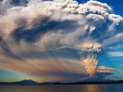
Managing Volcanic Hazards
Volcanoes create powerful hazards, from ash and lava to deadly gases. This GCSE Geography quiz looks at how people prepare for eruptions and reduce their risks.
1 .
Volcanic eruptions can have a devastating effect on communities and the environment yet people still live close to volcanoes and volcanically-active areas. Which of the following is not a reason for this?
Mudflows clear areas of woodland or agriculture
When volcanic ash weathers, it releases nutrients into the soil
Underground heat
Tourists like to visit volcanoes
The heat underground can be used to generate geothermal energy, the extra nutrients in soil make them more fertile and tourism brings cash into the local economy
2 .
There are several reasons why communities in LEDCs are more vulnerable than those in MEDCs. Which of the following statements is false?
Volcanoes in LEDCs erupt less often than in MEDCs so they are not as used to dealing with eruptions
Active volcanoes are often better monitored
The government can issue warnings via TV and radio a few days before an eruption
Fewer people have motor vehicles and the roads are often a lot worse in LEDCs
Rural populations in LEDCs have less access to broadcast media and so warnings may not reach them before the eruption occurs
3 .
Montserrat is a small island in the Caribbean and is a LEDC. A volcano on the south of the island started to give warning signs that an eruption was imminent. Two years later, the most intense eruptions occurred, however, there had been plenty of time to evacuate the population from the island. Which of the following would be classed as a long term response or result of the eruption?
Evacuation
Abandonment of the capital city
Building an observatory to monitor the volcano
Increased unemployment because tourists stopped visiting the island
Since the volcano has calmed down again, the tourist industry has recovered
4 .
Why are more people likely to die when a volcanic eruption occurs in a poor country?
They don't have the technology to monitor volcanoes closely
They don't have the resources to support the populations affected
Poor communications and infrastructure make evacuation slow and inefficient
All of the above
Monitoring is not as effective as in countries that are wealthy so there is a lot less warning before an eruption occurs, taking people by surprise. Aid often needs to come in from abroad and that always takes several days to organise
5 .
Which type of volcano is most likely to cause loss of life and property when it erupts?
Shield
Sword
Composite
Fissure
Sword is not a type of volcano. The lava from shield volcanoes is much less viscous than in a composite volcano and therefore eruptions are less explosive
6 .
Which of the following would be classed as a secondary effect of a volcanic eruption?
Destruction of crops and livestock by flooding where volcanic ash blocks rivers
Forests destroyed by a nuée ardente
People killed by toxic gases
Lahars destroying crops and homes
A secondary effect is something that is not caused directly by the eruption. In this case, although the flooding is caused by the ash, the destruction is actually caused by the water and not the eruption
7 .
What is the most effective way to protect a population during a volcanic eruption?
Evacuation
Provide specially reinforced umbrellas to protect them from the volcanic bombs
Build a large wall around the centre of population
Provide volcano suits to protect them from the heat
The only way that a population can be protected is by evacuation. If the lava from an eruption is of the viscous (thick and slow moving) type then it may be possible to build a wall from pre-cast concrete blocks to deflect it, however, there are still the other dangers to contend with
8 .
In MEDCs, people living near volcanoes are generally better prepared for an eruption. Which of the following is the most likely reason?
People in MEDCs are wealthier and can buy homes that are built to withstand a volcanic eruption
People in LEDCs have lower literacy skills
People in MEDCs have more leisure time and can spend more time getting fit so that they can run away from an eruption
People in LEDCs cannot afford to leave their homes during an eruption
Preparing people for a volcanic eruption includes education. That is more difficult where literacy levels are low because fewer people can read leaflets and posters
9 .
Which of the following is not a hazard from a volcano?
Lahar
Lava flow
Storm surge
Ash cloud
There are other hazards too such as nuée ardentes, toxic gases and volcanic bombs
10 .
Some volcanoes are closely monitored for signs of an eruption. Which of the following is not an indicator that an eruption is likely to occur?
An increase in oxygen levels around the volcano indicates that magma is rising
Dozens or even hundreds of micro-earthquakes indicates that magma is rising
An increase in sulfur dioxide around the volcano as gases are released from the rising magma
Ground temperatures increase around the volcano as the red hot magma gets closer to the surface
Volcanoes emit many gases, but never oxygen


**Unlimited Quizzes Await You! 🚀**
Hey there, quiz champ! 🌟 You've already tackled today's free questions.
Ready for more?
Ready for more?
🔓 Unlock UNLIMITED Quizzes and challenge yourself every day. But that's
not all...
not all...
🔥 As a Subscriber you can join our thrilling "Daily Streak" against other
quizzers. Try to win a coveted spot on our Hall of Fame Page.
quizzers. Try to win a coveted spot on our Hall of Fame Page.
Don't miss out! Join us now and keep the fun rolling. 🎉
**Unlimited Quizzes Await You! 🚀**
Hey there, quiz champ! 🌟 You've already tackled today's free questions. Ready for more?
🔓 Unlock UNLIMITED Quizzes and challenge yourself every day. But that's not all...
🔥 As a Subscriber you can join our thrilling "Daily Streak" against other quizzers. Try to win a coveted spot on our Hall of Fame Page.
Don't miss out! Join us now and keep the fun rolling. 🎉
© Copyright 2016-2026 - Education Quizzes
Work Innovate Ltd - Design | Development |
Marketing