


Ask the AI Tutor
Need help with Natural Weather Hazards? Ask our AI Tutor!
AI Tutor - Lucy
Connecting with Tutor...
Please wait while we establish connection
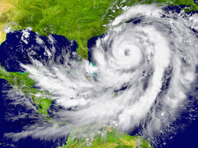
A hurricane is a tropical storm with sustained winds of 74mph.
Natural Weather Hazards
Weather can turn dangerous when storms, floods, or heatwaves strike. This GCSE Geography quiz explores natural weather hazards and how they affect people and places.
1 .
What is measured on the Beaufort scale?
Sea state
Tsunami wave height
Wind intensity
Sun strength
The Beaufort wind scale measures wind intensity based on observable parameters such as sea state. A glassy smooth sea corresponds to a 0 on the Beaufort scale, whereas a very rough sea state is equal to a 7 or 8 on the Beaufort scale, describing a near gale or gale
2 .
In 2005 Hurricane Katrina made landfall and struck the city of New Orleans. What caused the most damage to the city?
Flooding
High winds
Hail
Tornados
Around 80% of the city was flooded to some extent by the hurricane
3 .
Why do hurricanes form near the equator?
The Coriolis effect is strongest near the equator, meaning that the rotating winds needed to form hurricanes can form here
The equator is the longest stretch of uninterrupted ocean allowing for the wind to reach the required speeds
Hurricanes are driven by rising warm moist air. The oceans near the equator receive the most heat from the sun and so have the most energy
Similar storms form the world over, but they're only known as hurricanes on the equator
The Sun's rays strike the ocean's surface with the most power along the equator, meaning there is more energy available for hurricanes to form
4 .
What is a hurricane?
A tropical storm with sustained winds of 74mph
Any tropical storm that occurs during hurricane season
A storm that occurs in the mid-Atlantic region
A tropical storm that starts in the Atlantic and makes landfall on the American coast
Hurricane season begins on the 1st of June and ends on the 30th of November. This is the period when hurricanes are most likely to occur, although they do occur outside of this season
5 .
What lead to the worst effects of flooding in New Orleans after Hurricane Katrina?
The shape of the land encouraged the storm surge. The narrowing of the valley built the wave to greater heights which overtopped the levees, flooding the city
Being surrounded by water there was nowhere for the water to drain
The ground under the city is a heavy clay which stops water draining away. This lead to a build up of water that couldn't drain away via surface runoff as the water levels rose
The storm surge washed away the weaker levees built to the east and west of the city. Some were built on sandy porous soil which was easily washed away from under the constructed levees
Many of the neighbourhoods that were below sea level were the poorest and the most affected by flooding
6 .
Why are once rare events becoming more frequent?
As the climate warms up more energy is available for extreme weather events
We are able to measure events with more accuracy
Better media reporting means that we are seeing more of the events on the news
Weather events go in cycles
Global climate change means that there is more energy for hurricanes to form and more moisture in the atmosphere that returns as rain
7 .
How do tornados form?
As the winds swirl around the sides of steep valleys they on occasion loop back on themselves and begin to form a funnel cloud that eventually touches down and creates a tornado
As warm air from the ocean rises it moves up and away leaving an area of lower pressure underneath. Air rushes in to replace this air and so leads to strong winds
Descending air pulls down warm moist air which, as it comes into contact with the ground, spins around and starts a funnel at ground level. This grows as it rises and forms a tornado
Within a supercell thunderstorm, warm damp air and cold dry air move at different speeds leading to wind shear. This starts a pocket of air spinning which eventually forms a funnel
Because the conditions required to form a tornado are rare there are only specific locations worldwide where they regularly form, including Tornado Alley in the United States
8 .
How can increased and better forecasting mitigate the effects of natural weather hazards?
People feel more secure if they know what's happening
Prewarning allows people to evacuate areas at risk and prepare for the weather hazards
Weather forecasting allows governments to prepare to react in the long term
People have little confidence in the weather forecasts at present
Forecasting allowed New Orleans to be evacuated and for those that couldn't leave to take shelter in locations set aside as evacuation centres before the arrival of Hurricane Katrina in 2005
9 .
Why was New Orleans particularly exposed to the effects of Hurricane Katrina?
As a coastal city, it was overwhelmed by the storm surge
As a city with a high level of poverty, the houses were poorly built
The average elevation of the city is 2m below sea level
The bay funneled the storm surge up the valley to flood the city
New Orleans is completely surrounded by lakes, swamps and rivers. With over half the city being below sea level it was protected by levees
10 .
Why are people in the UK more likely to die in a blizzard than those in Canada, even if the blizzards are of the same strength and duration?
Blizzards affect Canada in different ways to the UK
As sustained blizzards are far more infrequent in the UK people are ill prepared
As the UK has an older population more deaths will occur
People have grown accustomed to milder weather in the UK and their immune systems can't cope when colder weather hits
Being unprepared for extreme weather, people may not have backup systems in case they lose their heating or electricity, may not have means of transport in poorer weather conditions and may not have food stocks in case of bad weather. In many areas search and rescue volunteers are used to get the sick and injured to safety as the other emergency services do not have the correct equipment


**Unlimited Quizzes Await You! 🚀**
Hey there, quiz champ! 🌟 You've already tackled today's free questions.
Ready for more?
Ready for more?
🔓 Unlock UNLIMITED Quizzes and challenge yourself every day. But that's
not all...
not all...
🔥 As a Subscriber you can join our thrilling "Daily Streak" against other
quizzers. Try to win a coveted spot on our Hall of Fame Page.
quizzers. Try to win a coveted spot on our Hall of Fame Page.
Don't miss out! Join us now and keep the fun rolling. 🎉
**Unlimited Quizzes Await You! 🚀**
Hey there, quiz champ! 🌟 You've already tackled today's free questions. Ready for more?
🔓 Unlock UNLIMITED Quizzes and challenge yourself every day. But that's not all...
🔥 As a Subscriber you can join our thrilling "Daily Streak" against other quizzers. Try to win a coveted spot on our Hall of Fame Page.
Don't miss out! Join us now and keep the fun rolling. 🎉
© Copyright 2016-2026 - Education Quizzes
Work Innovate Ltd - Design | Development |
Marketing